Trains and ferries cancelled as France on weather alert over ‘exceptional’ storm
Storm Ciaran, which forecasters say will be 'exceptionally intense' is predicted to hit northern France and the English Channel on Wednesday and Thursday, bringing winds of up to 140km/h, before moving to central then southern France.
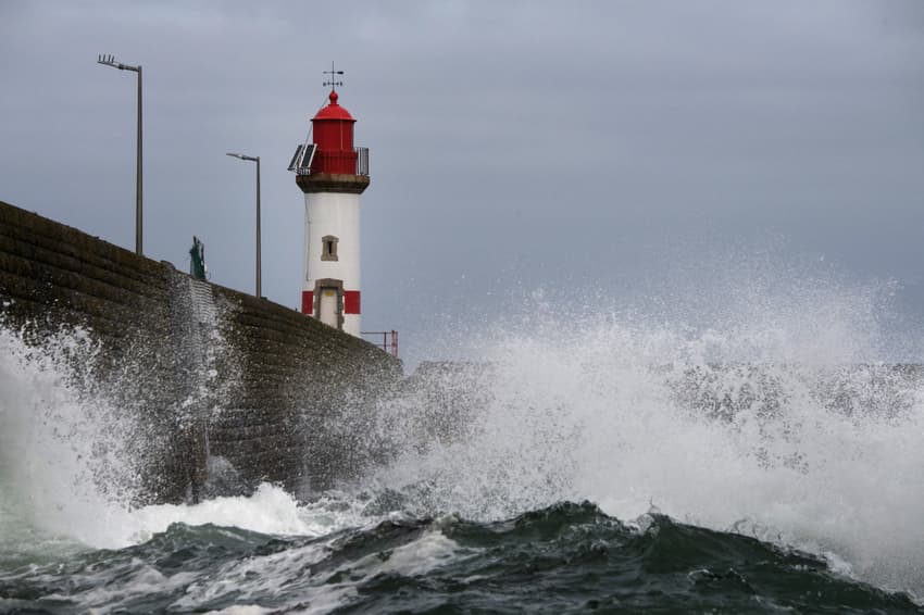
The storm is forecast to blow in from the west, hitting the northern and western French coastlines on Wednesday evening and continuing into Thursday. Weather warnings are also in place for southern England.
A total of 18 départements, mostly along France's western coastline, were on 'yellow' alert for possible flooding. Three départements in Brittany, the Morbihan, Finistère and Côtes d'Armor were on yellow alert for wind, while northern Corsica (Haute-Corse) was on 'orange' level alert for high winds.
🔶 1 département en Orange pic.twitter.com/n0YfNzTCzF
— VigiMétéoFrance (@VigiMeteoFrance) October 31, 2023
French rail operator SNCF announced on Tuesday that all local TER services in Hauts-de-France, Brittany, Normandy, Centre-Val-de-Loire and Pays-de-la-Loire (with the exception of the Paris Bercy-Nevers line, which will operate normally) will be cancelled between 10.30pm on Wednesday and 5am on Friday.
High-speed TGV services are not affected by the cancellations, but could be delayed or cancelled if flooding hits their routes.
The heavy rain and very high winds are also likely to affect ferry crossings on the Channel on Wednesday evening and Thursday, operator DFDS announced on Tuesday that several cross-Channel services had been cancelled due to "adverse weather".
Anyone with a trip booked should check with their operator before travelling to the port.
🌊 Une tempête "assez exceptionnelle" menace le quart nord-ouest de la France dans la nuit de mercredi à jeudi et jeudi matin, mais "son intensité et les zones les plus touchées restent à affiner".
Faisons le point complet ⤵️ @le_Parisien
1/11
👉https://t.co/nahZDWZFc2 pic.twitter.com/v1TvnhJW5Q
— Nicolas Berrod (@nicolasberrod) October 29, 2023
"Storm Ciarán will approach the coast of Brittany on Wednesday evening, then move inland across the north-western quarter of France. Strong gusts of wind are expected from Wednesday evening until midday on Thursday: between 100km/h and 110 km/h inland and between 120km/h and 140 km/h on the Brittany and Channel coasts, with gusts of up to 150 km/h," Météo France said in a new report published on Monday evening.
🌬️Entre mercredi soir et jeudi matin, la tempête #ciaran va toucher le quart Nord-Ouest du pays avec de très fortes rafales de vent.
🌊Attention également au risque de vagues submersion sur toute la façade atlantique et la Manche
Notre point complet 👉https://t.co/09XlTyKanI pic.twitter.com/UwJoUrbxRz
— Météo-France (@meteofrance) October 30, 2023
The storm is then predicted to move south, with central and northern France - including the Paris region - affected on Thursday and the south west hit on Friday, along with very heavy rain on the island of Corsica.
At present it is not yet clear whether or not the storm will decrease in intensity through Thursday and Friday, said Météo France.
🌬️⚠️Entre mercredi et jeudi, possibilité de vents violents dans l'Ouest liés à la dépression #Ciaran nommée par le @metoffice.
➡️Creusement "d'école", engendré par l'interaction courant-jet d'altitude/tourbillon près de la surface.
❓Incertitudes sur trajectoire et intensité.
1/2 pic.twitter.com/PYFG9KZLum
— Météo-France Ouest (@MeteoFrance_O) October 29, 2023
Interior minister Gérald Darmanin announced on Monday that he was cancelling a planned overseas trip because of the forecast storm, saying that "in order to coordinate the mobilisation of all government services, particularly the emergency services" he was delaying for two weeks a trip to the French overseas territory of Mayotte.
Guillaume Séchet, founder of the site meteo-villes.com, told Le Parisien: "For a day or two now we've seen a quite exceptional storm forming."
"As much as there were discrepancies between the models on Saturday, we really have to take this one seriously," added Dorian Dziadula, forecaster for the Infoclimat website. "The fact that a storm will arrive from the west on Wednesday night seems to be a given, but its intensity and the areas most affected still need to be refined."
The UK's Met office is predicting winds of up to 145 km/h along the south coast of England, and very heavy rain, on Wednesday evening and Thursday.
Comments
See Also
The storm is forecast to blow in from the west, hitting the northern and western French coastlines on Wednesday evening and continuing into Thursday. Weather warnings are also in place for southern England.
A total of 18 départements, mostly along France's western coastline, were on 'yellow' alert for possible flooding. Three départements in Brittany, the Morbihan, Finistère and Côtes d'Armor were on yellow alert for wind, while northern Corsica (Haute-Corse) was on 'orange' level alert for high winds.
🔶 1 département en Orange pic.twitter.com/n0YfNzTCzF
— VigiMétéoFrance (@VigiMeteoFrance) October 31, 2023
French rail operator SNCF announced on Tuesday that all local TER services in Hauts-de-France, Brittany, Normandy, Centre-Val-de-Loire and Pays-de-la-Loire (with the exception of the Paris Bercy-Nevers line, which will operate normally) will be cancelled between 10.30pm on Wednesday and 5am on Friday.
High-speed TGV services are not affected by the cancellations, but could be delayed or cancelled if flooding hits their routes.
The heavy rain and very high winds are also likely to affect ferry crossings on the Channel on Wednesday evening and Thursday, operator DFDS announced on Tuesday that several cross-Channel services had been cancelled due to "adverse weather".
Anyone with a trip booked should check with their operator before travelling to the port.
🌊 Une tempête "assez exceptionnelle" menace le quart nord-ouest de la France dans la nuit de mercredi à jeudi et jeudi matin, mais "son intensité et les zones les plus touchées restent à affiner".
— Nicolas Berrod (@nicolasberrod) October 29, 2023
Faisons le point complet ⤵️ @le_Parisien
1/11
👉https://t.co/nahZDWZFc2 pic.twitter.com/v1TvnhJW5Q
"Storm Ciarán will approach the coast of Brittany on Wednesday evening, then move inland across the north-western quarter of France. Strong gusts of wind are expected from Wednesday evening until midday on Thursday: between 100km/h and 110 km/h inland and between 120km/h and 140 km/h on the Brittany and Channel coasts, with gusts of up to 150 km/h," Météo France said in a new report published on Monday evening.
🌬️Entre mercredi soir et jeudi matin, la tempête #ciaran va toucher le quart Nord-Ouest du pays avec de très fortes rafales de vent.
— Météo-France (@meteofrance) October 30, 2023
🌊Attention également au risque de vagues submersion sur toute la façade atlantique et la Manche
Notre point complet 👉https://t.co/09XlTyKanI pic.twitter.com/UwJoUrbxRz
The storm is then predicted to move south, with central and northern France - including the Paris region - affected on Thursday and the south west hit on Friday, along with very heavy rain on the island of Corsica.
At present it is not yet clear whether or not the storm will decrease in intensity through Thursday and Friday, said Météo France.
🌬️⚠️Entre mercredi et jeudi, possibilité de vents violents dans l'Ouest liés à la dépression #Ciaran nommée par le @metoffice.
— Météo-France Ouest (@MeteoFrance_O) October 29, 2023
➡️Creusement "d'école", engendré par l'interaction courant-jet d'altitude/tourbillon près de la surface.
❓Incertitudes sur trajectoire et intensité.
1/2 pic.twitter.com/PYFG9KZLum
Interior minister Gérald Darmanin announced on Monday that he was cancelling a planned overseas trip because of the forecast storm, saying that "in order to coordinate the mobilisation of all government services, particularly the emergency services" he was delaying for two weeks a trip to the French overseas territory of Mayotte.
Guillaume Séchet, founder of the site meteo-villes.com, told Le Parisien: "For a day or two now we've seen a quite exceptional storm forming."
"As much as there were discrepancies between the models on Saturday, we really have to take this one seriously," added Dorian Dziadula, forecaster for the Infoclimat website. "The fact that a storm will arrive from the west on Wednesday night seems to be a given, but its intensity and the areas most affected still need to be refined."
The UK's Met office is predicting winds of up to 145 km/h along the south coast of England, and very heavy rain, on Wednesday evening and Thursday.
Join the conversation in our comments section below. Share your own views and experience and if you have a question or suggestion for our journalists then email us at [email protected].
Please keep comments civil, constructive and on topic – and make sure to read our terms of use before getting involved.
Please log in here to leave a comment.