Published: 14 Jun, 2021 CET.Updated: Mon 14 Jun 2021 18:00 CET
Sunbathers in Copenhagen enjoy a heatwave at start of August in 2020. Photo: Claus Bech/Ritzau Scanpix
Large swathes of Denmark, including the capital Copenhagen will be basking in tropical temperatures of around 30C on Thursday and Friday as the country enjoys the first heat wave of the summer.
"The combination of the warm air and largely cloudless weather will give rise to heatwaves in parts of the southern and eastern areas of the country," predicted meteorologist Lars Holtmann.
Advertisement
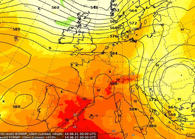
Here you can see the heat coming north from Africa. Source: DMI
According to the broadcaster TV2, if 30C temperatures are recorded on Thursday, it will be the earliest so-called "tropical day" in 14 years. A tropical day is defined as a day when 30C is recorded somewhere in Denmark.
The broadcaster also predicted that there might be "tropical nights", defined as a night when the temperature does not fall below 20C.
The hot spell is expected to climax in thunderstorms over the weekend, with cooler weather resuming next week.
"The collision of the cooler air from the west and the very hot air mass from the east provides favourable conditions for strong thunderstorms to form," TV2 explained. "Right now, the greatest risk is in Jutland."
Join the conversation in our comments section below. Share your own views and experience and if you have a question or suggestion for our journalists then email us at [email protected].
Please keep comments civil, constructive and on topic – and make sure to read our terms of use before getting involved.

 Here you can see the heat coming north from Africa. Source: DMI
Join the conversation in our comments section below. Share your own views and experience and if you have a question or suggestion for our journalists then email us at [email protected].
Please keep comments civil, constructive and on topic – and make sure to read our terms of use before getting involved.
Please log in here to leave a comment.