Weather warning: Swathe of Switzerland faces heavy snow and gales
Although winter doesn't officially start until December 21st, strong winds, snow, and low temperatures are already hitting parts of Switzerland.
A low pressure system that has formed in the Mediterranean is directing a large mass of humid, cool air towards Switzerland Friday and over the weekend, the Federal Office of Meteorology and Climatology (MeteoSwiss) warned.
Strong winds are blowing in Alpine valleys and in the mountains, with gusts of up to 120 kilometres per hour.
Le #blogmeteosuisse du jour fait le point sur les fortes précipitations en vue sur les Alpes dès cette nuit et ce week-end, donnant des quantités de #neige fraîche abondantes, en particulier sur le Sud des Alpes. https://t.co/EXNo3lVRbe #MétéoSuisse #meteo #snowfall pic.twitter.com/3MblurBihc
— MétéoSuisse (@meteosuisse) December 3, 2020
The snowline is expected at between 500 and 800m above sea level, but it could drop lower in some regions.
The snowfall between 30 and 40 cm could could blanket the Jura and the Western Alps above 1000 metres.
South of the Alps, up to 80 cm are expected from 600 meters by Sunday.
These forecasts prompted the meteorological agency to issue a 3/5 degree danger warning for much of French-speaking Switzerland and a 4/5 degree warning for Ticino and parts of Graubünden.
The hazard categories are numbered 1 to 5, with 5 being the most severe one.
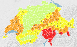 This map shows which regions will be most affected by bad weather this weekend, with 4 rated as heaviest-hit. Chart by MeteoSwiss.
Comments
See Also
A low pressure system that has formed in the Mediterranean is directing a large mass of humid, cool air towards Switzerland Friday and over the weekend, the Federal Office of Meteorology and Climatology (MeteoSwiss) warned.
Strong winds are blowing in Alpine valleys and in the mountains, with gusts of up to 120 kilometres per hour.
Le #blogmeteosuisse du jour fait le point sur les fortes précipitations en vue sur les Alpes dès cette nuit et ce week-end, donnant des quantités de #neige fraîche abondantes, en particulier sur le Sud des Alpes. https://t.co/EXNo3lVRbe #MétéoSuisse #meteo #snowfall pic.twitter.com/3MblurBihc
— MétéoSuisse (@meteosuisse) December 3, 2020
The snowline is expected at between 500 and 800m above sea level, but it could drop lower in some regions.
The snowfall between 30 and 40 cm could could blanket the Jura and the Western Alps above 1000 metres.
South of the Alps, up to 80 cm are expected from 600 meters by Sunday.
These forecasts prompted the meteorological agency to issue a 3/5 degree danger warning for much of French-speaking Switzerland and a 4/5 degree warning for Ticino and parts of Graubünden.
The hazard categories are numbered 1 to 5, with 5 being the most severe one.
This map shows which regions will be most affected by bad weather this weekend, with 4 rated as heaviest-hit. Chart by MeteoSwiss.
Join the conversation in our comments section below. Share your own views and experience and if you have a question or suggestion for our journalists then email us at [email protected].
Please keep comments civil, constructive and on topic – and make sure to read our terms of use before getting involved.
Please log in here to leave a comment.