MAP: Where are Norway’s coronavirus hotspots?
This map shows where coronavirus cases are currently most prevalent in Norway.
On Monday, authorities in capital Oslo announced new measures, primarily aimed at teenagers, in an effort to reduce the spread of coronavirus infections in the city.
The new restrictions are added to a ‘social lockdown’ already in place in Oslo.
The ‘social lockdown', which came into effect last Tuesday, means the closure of a broad section of sports and culture facilities, assembly limitations, as well as a ban on serving alcohol at all times.
2,204 people in Oslo have registered positive tests for Covid-19 during the last two weeks, according to Oslo Municipality figures.
READ ALSO:
-
Why coronavirus restrictions in Oslo are yet to affect infection numbers
-
'This situation is really demanding for a lot of people': Oslo residents on living with social lockdown
In addition to Oslo, strict local measures are also in place in Bergen, while a third city, Drammen, is now also reporting significantly increased numbers of Covid-19 cases compared to the rest of the country. In Drammen, 60 people tested positive for Covid-19 in the last 24 hours, NRK reported on Tuesday morning.
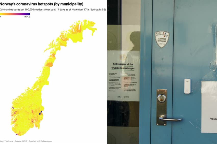
The following map shows the new infections per 100,000 residents for the last two weeks up until Tuesday, November 17th (scroll over for numbers and municipality name).
It should be noted that municipalities with very small population sizes will show a high value for the measure even if they have only a handful of cases.
The data comes from the Norwegian Institute of Public Health’s registration system, MSIS.
Comments
See Also
On Monday, authorities in capital Oslo announced new measures, primarily aimed at teenagers, in an effort to reduce the spread of coronavirus infections in the city.
The new restrictions are added to a ‘social lockdown’ already in place in Oslo.
The ‘social lockdown', which came into effect last Tuesday, means the closure of a broad section of sports and culture facilities, assembly limitations, as well as a ban on serving alcohol at all times.
2,204 people in Oslo have registered positive tests for Covid-19 during the last two weeks, according to Oslo Municipality figures.
READ ALSO:
- Why coronavirus restrictions in Oslo are yet to affect infection numbers
- 'This situation is really demanding for a lot of people': Oslo residents on living with social lockdown
In addition to Oslo, strict local measures are also in place in Bergen, while a third city, Drammen, is now also reporting significantly increased numbers of Covid-19 cases compared to the rest of the country. In Drammen, 60 people tested positive for Covid-19 in the last 24 hours, NRK reported on Tuesday morning.
The following map shows the new infections per 100,000 residents for the last two weeks up until Tuesday, November 17th (scroll over for numbers and municipality name).
It should be noted that municipalities with very small population sizes will show a high value for the measure even if they have only a handful of cases.
The data comes from the Norwegian Institute of Public Health’s registration system, MSIS.
Join the conversation in our comments section below. Share your own views and experience and if you have a question or suggestion for our journalists then email us at [email protected].
Please keep comments civil, constructive and on topic – and make sure to read our terms of use before getting involved.
Please log in here to leave a comment.