Seven diverse maps that help explain Berlin
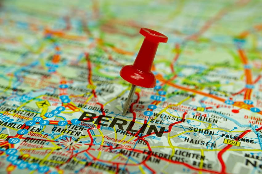
Berlin is a vibrant, multicultural city with a long history. Here's a breakdown of some of the most important aspects of the German capital.
Berlin, an artistic and cultural powerhouse, is Germany's capital as well as its most populous city with almost 3.75 million inhabitants. The seat of the nation's government is located here, making the city politically vital for the rest of Europe.
The capital is also known for its growing tech industry, especially in the fields of clean energy and pharmaceuticals.
Let's start with the basics.
Location in Germany
Berlin is in East Germany and is a city as well as a state. It is completely surrounded by another German Bundesland called Brandenburg. Potsdam, Brandenburg's capital, borders Berlin and makes up the Berlin/Brandenburg Metropolitan Region with a population of six million.
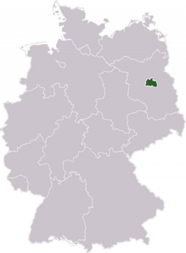
Source: Wikimedia
Because of its location in East Germany, Berlin was surrounded by the Deutschen Demokratischen Republik, or DDR, following World War II. West Berlin, occupied by Western Allies, was seen as a capitalist island in the Soviet sector.
READ ALSO: East Germany - 10 things you never knew about the GDR
12 Districts
Berlin has 12 districts, or Bezirke. These are Spandau, Reinickendorf, Charlottenburg-Wilmersdorf, Steglitz-Zehlendorf, Tempelhof-Schöneberg, Neukölln, Lichtenberg, Mitte, Friedrichshain-Kreuzberg, Pankow, Treptow-Köpenick and Marzahn-Hellersdorf.
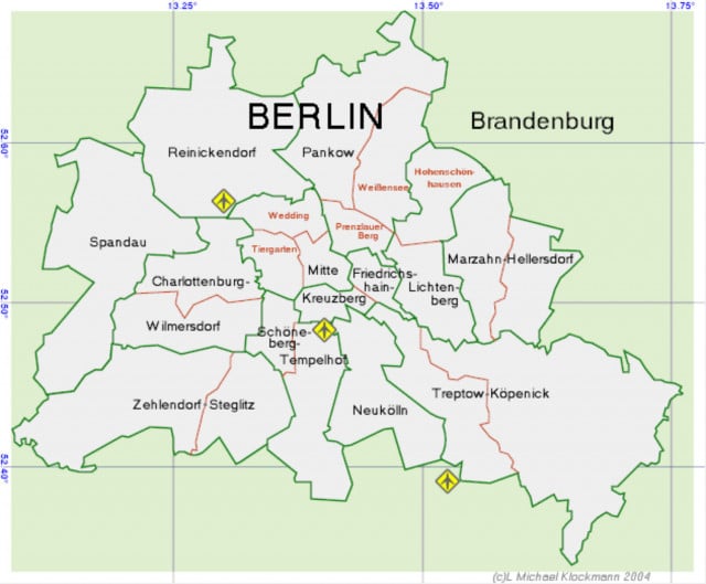
Source: Wikimedia
Each Bezirk has its own small governing body and mayor, which advise the greater Berlin Senate. Additionally, each district is its own microcosm of culture and business.
Many Germans will ask which Bezirk you live in and then let you know exactly what they think of the area. In Berlin, the word Kiez is also commonly used to refer to the different neighbourhoods and boroughs.
READ ALSO: German word of the day: Der Kiez
A focus on public transport
Berlin is a mobile city. From the U-bahn to the Straßenbahn, the districts are often easier to navigate with public transport than with a car.
Arguably the most famous public train in Berlin is the S-bahn or "Ringbahn," which encompasses the inner city with its tracks. Because of its shape, it is also sometimes referred to as the Hundekopf, or dog's head.
The inside of the ring makes up the "A" section of the BVG's services. Living outside the "ring" used to have a certain negative stigma, but this is fading over time as the city expands and the costs of living push people further from the centre.
READ ALSO: People think life in Berlin ends outside the Ringbahn. They're wrong.
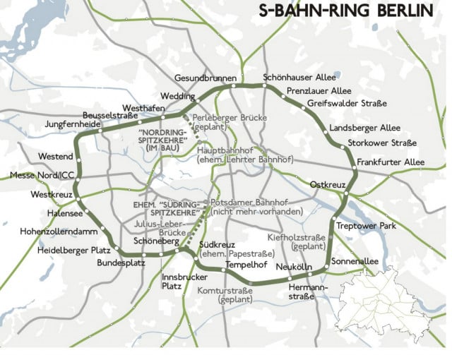 Source: Wikimedia
According to a 2017 report from Berlin's Environment, Transport and Climate Protection committee, there are only about 326 cars per 1000 inhabitants. For context, the same number of residents own 850 bicycles.
The city is also undeniably green. Large parks like Tiergarten and tree-lined streets and rivers run through the inner city.
READ ALSO: A guide to Berlin's hidden swimming spots - from the woman who wrote a book on it
Rent
While Berlin is known for its relatively reasonable cost of living, skyrocketing rents have captured international attention in the last years. The recently passed rent cap, or Mietendeckel, freezes and caps rents for certain buildings throughout the city for five years.
READ ALSO: In graphs: How gentrification has changed Berlin
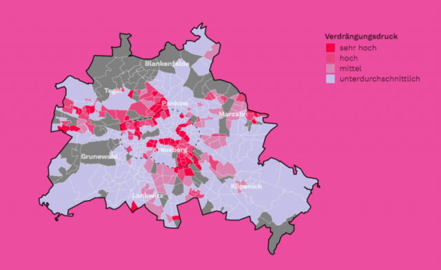 This image shows the increasing price pressure ousting renters. Source: Mietendwatch.de (Screenshot)
Unfortunately, the pressure and competitiveness of Berlin's housing market remains high. This map showcases the areas where current renters are facing the most price inflation, and therefore the most pressure to move out and live elsewhere.
READ ALSO: Berlin to freeze rent for five years: What you need to know
History
The earliest building artifacts found in the Berlin area date back to the second half of the 1100s. Around this time, the small settlement of Cölln existed on an island on the Spree river while Berlin's Nikolaiviertel lay on the other side. A medieval wall protected both. However, the official founding of the city of Berlin is 1237.
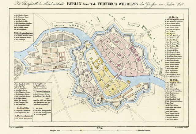
Source: J. M. F. Schmidt/Landesbibliothek Berlin via Wikimedia
The map above is from the year 1688, when kings of the Hohenzollern dynasty ruled over Brandenburg-Prussia.
READ ALSO: Weekend Wanderlust: Discovering the original Wall in Medieval Berlin
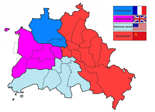
Divided city
After World War II, Berlin faced incredible bombing destruction and consequent population decline. The city was divided into four sectors by Allied forces. The British, French and American sectors made up West Berlin, while the Soviets controlled the East.
West Berlin was completely surrounded by East Berlin and the DDR. West Berlin was only connected to the Bundesrepublik Deutschland, or West Germany, through narrow transit lines.
The divisions between East and West became more restricted and dangerous as an increasing number of Eastern Germans fled the DDR, usually through West Berlin. Cold War tensions from the US only increased the strain.
Source: Paasikivi via Wikimedia
Eventually this culminated in the creation of the inner German separating all of Germany. And in 1961, the Berlin Wall was built.
This devastating separation cut the city in half for almost thirty years. Berlin still bares the architectural marks of the different regimes, with starkly contrasting buildings in East and West.
November 9th this year marked the 30th anniversary of the Mauerfall, or the fall of the Berlin Wall. Read more here.
Wi-Fi...sort of
You may have read about Germany's spotty wifi and rural dead zones recently. However, Berlin generally has good connections... and a good sense of humour. Here is a map of Berlin's best Wi-Fi names, put together by Italian expat Federico Prandi.
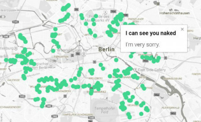
Map by Federico Prandi (Screenshot)
Top honours go to "It hurts when IP," "I'm missing a pair of socks" and "Nutella Man."
See the full interactive map here.
Comments
See Also
Berlin, an artistic and cultural powerhouse, is Germany's capital as well as its most populous city with almost 3.75 million inhabitants. The seat of the nation's government is located here, making the city politically vital for the rest of Europe.
The capital is also known for its growing tech industry, especially in the fields of clean energy and pharmaceuticals.
Let's start with the basics.
Location in Germany
Berlin is in East Germany and is a city as well as a state. It is completely surrounded by another German Bundesland called Brandenburg. Potsdam, Brandenburg's capital, borders Berlin and makes up the Berlin/Brandenburg Metropolitan Region with a population of six million.
Source: Wikimedia
Because of its location in East Germany, Berlin was surrounded by the Deutschen Demokratischen Republik, or DDR, following World War II. West Berlin, occupied by Western Allies, was seen as a capitalist island in the Soviet sector.
READ ALSO: East Germany - 10 things you never knew about the GDR
12 Districts
Berlin has 12 districts, or Bezirke. These are Spandau, Reinickendorf, Charlottenburg-Wilmersdorf, Steglitz-Zehlendorf, Tempelhof-Schöneberg, Neukölln, Lichtenberg, Mitte, Friedrichshain-Kreuzberg, Pankow, Treptow-Köpenick and Marzahn-Hellersdorf.
Source: Wikimedia
Each Bezirk has its own small governing body and mayor, which advise the greater Berlin Senate. Additionally, each district is its own microcosm of culture and business.
Many Germans will ask which Bezirk you live in and then let you know exactly what they think of the area. In Berlin, the word Kiez is also commonly used to refer to the different neighbourhoods and boroughs.
READ ALSO: German word of the day: Der Kiez
A focus on public transport
Berlin is a mobile city. From the U-bahn to the Straßenbahn, the districts are often easier to navigate with public transport than with a car.
Arguably the most famous public train in Berlin is the S-bahn or "Ringbahn," which encompasses the inner city with its tracks. Because of its shape, it is also sometimes referred to as the Hundekopf, or dog's head.
The inside of the ring makes up the "A" section of the BVG's services. Living outside the "ring" used to have a certain negative stigma, but this is fading over time as the city expands and the costs of living push people further from the centre.
READ ALSO: People think life in Berlin ends outside the Ringbahn. They're wrong.
Source: Wikimedia
According to a 2017 report from Berlin's Environment, Transport and Climate Protection committee, there are only about 326 cars per 1000 inhabitants. For context, the same number of residents own 850 bicycles.
The city is also undeniably green. Large parks like Tiergarten and tree-lined streets and rivers run through the inner city.
READ ALSO: A guide to Berlin's hidden swimming spots - from the woman who wrote a book on it
Rent
While Berlin is known for its relatively reasonable cost of living, skyrocketing rents have captured international attention in the last years. The recently passed rent cap, or Mietendeckel, freezes and caps rents for certain buildings throughout the city for five years.
READ ALSO: In graphs: How gentrification has changed Berlin
This image shows the increasing price pressure ousting renters. Source: Mietendwatch.de (Screenshot)
Unfortunately, the pressure and competitiveness of Berlin's housing market remains high. This map showcases the areas where current renters are facing the most price inflation, and therefore the most pressure to move out and live elsewhere.
READ ALSO: Berlin to freeze rent for five years: What you need to know
History
The earliest building artifacts found in the Berlin area date back to the second half of the 1100s. Around this time, the small settlement of Cölln existed on an island on the Spree river while Berlin's Nikolaiviertel lay on the other side. A medieval wall protected both. However, the official founding of the city of Berlin is 1237.
Source: J. M. F. Schmidt/Landesbibliothek Berlin via Wikimedia
The map above is from the year 1688, when kings of the Hohenzollern dynasty ruled over Brandenburg-Prussia.
READ ALSO: Weekend Wanderlust: Discovering the original Wall in Medieval Berlin
Divided city
After World War II, Berlin faced incredible bombing destruction and consequent population decline. The city was divided into four sectors by Allied forces. The British, French and American sectors made up West Berlin, while the Soviets controlled the East.
West Berlin was completely surrounded by East Berlin and the DDR. West Berlin was only connected to the Bundesrepublik Deutschland, or West Germany, through narrow transit lines.
The divisions between East and West became more restricted and dangerous as an increasing number of Eastern Germans fled the DDR, usually through West Berlin. Cold War tensions from the US only increased the strain.
Source: Paasikivi via Wikimedia
Eventually this culminated in the creation of the inner German separating all of Germany. And in 1961, the Berlin Wall was built.
This devastating separation cut the city in half for almost thirty years. Berlin still bares the architectural marks of the different regimes, with starkly contrasting buildings in East and West.
November 9th this year marked the 30th anniversary of the Mauerfall, or the fall of the Berlin Wall. Read more here.
Wi-Fi...sort of
You may have read about Germany's spotty wifi and rural dead zones recently. However, Berlin generally has good connections... and a good sense of humour. Here is a map of Berlin's best Wi-Fi names, put together by Italian expat Federico Prandi.
Map by Federico Prandi (Screenshot)
Top honours go to "It hurts when IP," "I'm missing a pair of socks" and "Nutella Man."
See the full interactive map here.
Join the conversation in our comments section below. Share your own views and experience and if you have a question or suggestion for our journalists then email us at [email protected].
Please keep comments civil, constructive and on topic – and make sure to read our terms of use before getting involved.
Please log in here to leave a comment.