Seven maps that help explain Bavaria
The largest state in Germany, Bavaria was also its own kingdom for many years. Here's a breakdown of the Bundesland using maps.
Bavaria may be the home of all things considered stereotypically German: beer gardens, Lederhosen, Volksmusik and the Nuremberg Christmas Market. Even the famous Reinheitsgebot, or beer purity law that only allows the use of three ingredients (water, barley and hops) has origins in Bavaria.
READ ALSO: Why beer means so much to the Germans
The state's history stretches back well over 2000 years, from Celtic tribes to the Holy Roman Empire, creating a proud and traditional culture that attracts visitors from all over the world.
Here are the basics.
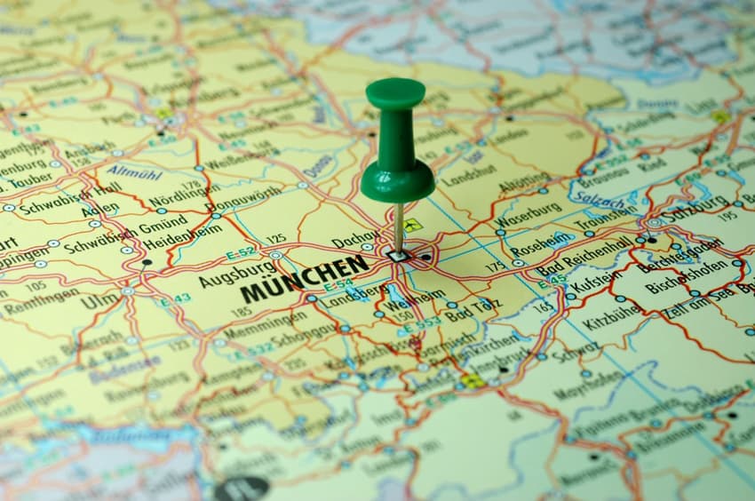
Location in Germany
Bavaria is located in the southeast corner of Germany and takes up around a fifth of the country's land mass. Baden-Württemberg forms a border on the west, Hesse to the northwest, and Thuringia and Saxony are in the north. Munich, with a population of nearly 1.5 million, is the state capital and the third-largest in Germany overall.
The state is bordered internationally by the Czech Republic to the east, Austria to the southeast, Lichtenstein to the south and Switzerland to the southwest.
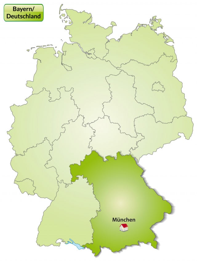
Source: Depositphotos/artalis
History
This is a look at the kingdom of Bavaria around 900 AD. Numerous families controlled the duchy throughout this time, but the area lost large tracts of land around 975, coinciding with the founding of Austria.
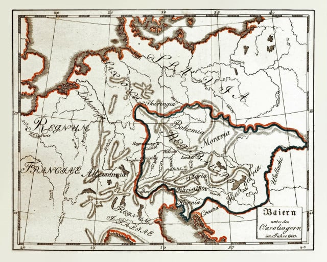
Source: Johann Christoph von Aretin/Alois Senefelder via Wikimedia
Even earlier, Bavaria was controlled by Celtic tribes and then the Roman Empire. After the period of duchy control showed on this map, Bavaria was incorporated into the Holy Roman Empire, then became an independent kingdom, was part of Prussia's German Empire, and was finally incorporated into the Bundesrepublik in 1949.
Geography
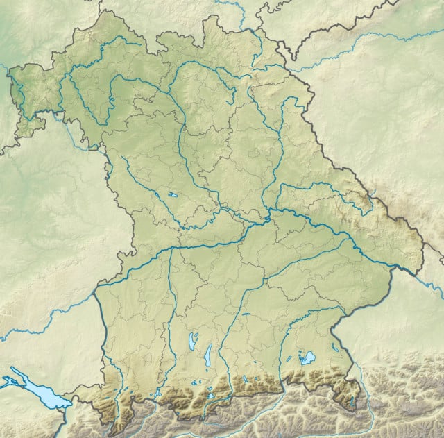
Source: Von Grundkarte TUBS via Wikimedia
The Bavarian alps form the border between Germany and Austria. This mountain range is also home to Germany's tallest mountain, the Zugspitze near the Austrian border. The famous Garmisch-Partenkirchen ski resort is located here as well, although there are many other options for skiing in the state.
Cultural heritage
This map shows a selection of Bavaria's most well-known castles. Neuschwanstein Castle, located far south near the Bavarian Alps, is one of the most famous castles in Europe.
READ ALSO: 10 surprising facts you should know about Neuschwanstein Castle
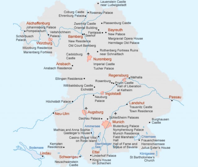
Source: Bayerische Verwaltung der Stattlichen Schlösser, Gärten und Seen (Screenshot)
It was built by King Ludwig II, who was sometimes referred to as the Märchenkönig (Fairy Tale King) because of his extravagant palaces. Nymphenburg Palace in Munich and Burghausen Castle (which is longest castle complex in the world, according to Guinness) are among the other famous Bavarian attractions.
Population
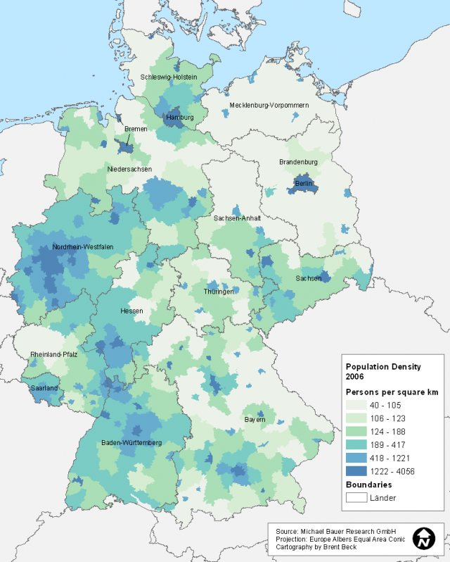 Source: Wikimedia
Bavaria's power comes mostly from its land mass. Since it is not densely populated, it is only through its large size that it retains its place as the second most populous German state, behind only NRW.
Bavaria has a large number of Catholics and is has the second-lowest population of nonreligious individuals in all of Germany. The state is known as rather conservative and has a CSU majority (the CSU is the Bavarian sister party to Germany's CDU).
A wealthy state
Source: Wikimedia
Bavaria's power comes mostly from its land mass. Since it is not densely populated, it is only through its large size that it retains its place as the second most populous German state, behind only NRW.
Bavaria has a large number of Catholics and is has the second-lowest population of nonreligious individuals in all of Germany. The state is known as rather conservative and has a CSU majority (the CSU is the Bavarian sister party to Germany's CDU).
A wealthy state
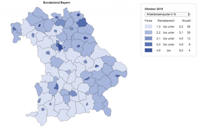 Source: Statistik und Arbeitsmarktberichterstattung der Bundesagentur für Arbeit
Unlike NRW, which has high unemployment due to the weakening of the coal and steel industry, the western state of Bavaria has retained its wealth, especially in comparison to eastern German states. In 2018, Bavaria contributed the most to poorer eastern states through a yearly process known as the Länderfinanzausgleich, or "state financial equalization."
Weißwurstäquator
Finally, we arrive at the "White Sausage Equator," a tongue-in-cheek term used to describe the cultural difference between Southern Bavaria and Northern or Central Germany. The border is named after the traditional Bavarian Weißwurst, a staple dish in the region.
Source: Statistik und Arbeitsmarktberichterstattung der Bundesagentur für Arbeit
Unlike NRW, which has high unemployment due to the weakening of the coal and steel industry, the western state of Bavaria has retained its wealth, especially in comparison to eastern German states. In 2018, Bavaria contributed the most to poorer eastern states through a yearly process known as the Länderfinanzausgleich, or "state financial equalization."
Weißwurstäquator
Finally, we arrive at the "White Sausage Equator," a tongue-in-cheek term used to describe the cultural difference between Southern Bavaria and Northern or Central Germany. The border is named after the traditional Bavarian Weißwurst, a staple dish in the region.
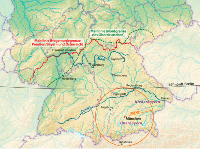 Source: By NordNordWest via Wikimedia (Screenshot)
The most commonly referenced border follows the Danube river. However, others put the border farther north along the Main river, at another famous dialect border called the Speyer line, or at the 49th parallel latitude. Finally, another description of this "cultural border" forms a ring around Munich.
Source: By NordNordWest via Wikimedia (Screenshot)
The most commonly referenced border follows the Danube river. However, others put the border farther north along the Main river, at another famous dialect border called the Speyer line, or at the 49th parallel latitude. Finally, another description of this "cultural border" forms a ring around Munich.
Comments (1)
See Also
Bavaria may be the home of all things considered stereotypically German: beer gardens, Lederhosen, Volksmusik and the Nuremberg Christmas Market. Even the famous Reinheitsgebot, or beer purity law that only allows the use of three ingredients (water, barley and hops) has origins in Bavaria.
READ ALSO: Why beer means so much to the Germans
The state's history stretches back well over 2000 years, from Celtic tribes to the Holy Roman Empire, creating a proud and traditional culture that attracts visitors from all over the world.
Here are the basics.
Location in Germany
Bavaria is located in the southeast corner of Germany and takes up around a fifth of the country's land mass. Baden-Württemberg forms a border on the west, Hesse to the northwest, and Thuringia and Saxony are in the north. Munich, with a population of nearly 1.5 million, is the state capital and the third-largest in Germany overall.
The state is bordered internationally by the Czech Republic to the east, Austria to the southeast, Lichtenstein to the south and Switzerland to the southwest.
Source: Depositphotos/artalis
History
This is a look at the kingdom of Bavaria around 900 AD. Numerous families controlled the duchy throughout this time, but the area lost large tracts of land around 975, coinciding with the founding of Austria.
Source: Johann Christoph von Aretin/Alois Senefelder via Wikimedia
Even earlier, Bavaria was controlled by Celtic tribes and then the Roman Empire. After the period of duchy control showed on this map, Bavaria was incorporated into the Holy Roman Empire, then became an independent kingdom, was part of Prussia's German Empire, and was finally incorporated into the Bundesrepublik in 1949.
Geography
Source: Von Grundkarte TUBS via Wikimedia
The Bavarian alps form the border between Germany and Austria. This mountain range is also home to Germany's tallest mountain, the Zugspitze near the Austrian border. The famous Garmisch-Partenkirchen ski resort is located here as well, although there are many other options for skiing in the state.
Cultural heritage
This map shows a selection of Bavaria's most well-known castles. Neuschwanstein Castle, located far south near the Bavarian Alps, is one of the most famous castles in Europe.
READ ALSO: 10 surprising facts you should know about Neuschwanstein Castle
Join the conversation in our comments section below. Share your own views and experience and if you have a question or suggestion for our journalists then email us at [email protected].
Please keep comments civil, constructive and on topic – and make sure to read our terms of use before getting involved.
Please log in here to leave a comment.