Storm Miguel: More weather warnings as western France braces for 130km/h winds
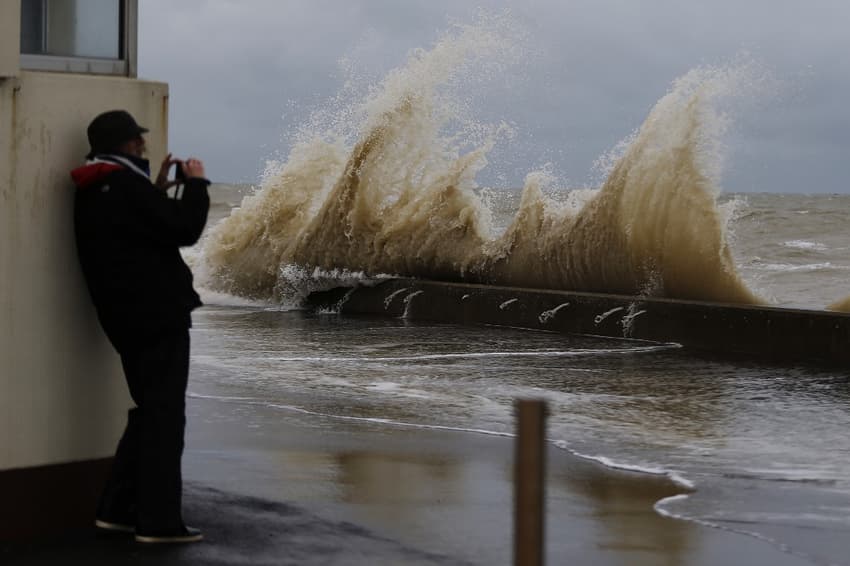
Western France is braced for storm force winds and yet more rain as Storm Miguel moves in on Friday morning.
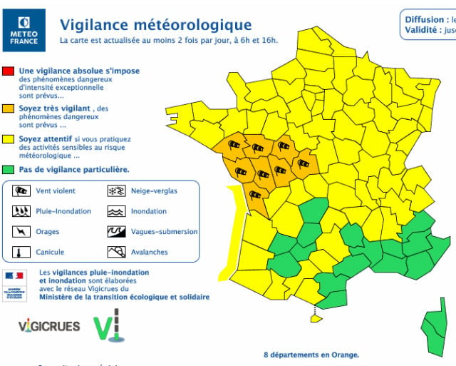
A total of 8 departments were placed on orange alert - the second highest warning - for storms by France's national weather agency Meteo France at 6am on Friday morning.
The departments affected are Charente-Maritime, Indre, Indre-et-Loire, Loire-Atlantique, Maine-et-Loire, Deux-Sèvres, Vendée and Vienne.
People in these areas are warned to take precautions due to the risk of dangerous weather conditions, with the warnings expected to remain in place until Saturday at 6am.
 Map: Meteo France
"It should deepen more and more during the night from Thursday to Friday in the Bay of Biscay," warns Frédéric Pluviaud, meteorologist at Météo France, based in Mérignac (Gironde), interviewed by French regional newspaper Sud Ouest.
Info #météo : la #tempête #Miguel se creuse à proximité du #CapFinisterre (#Espagne) et se dirige vers la #France !!! @NicolasLeFriant
Retrouvez toutes nos prévisions météorologiques sur l'application WeatherPro, disponible sur Android et iOS. pic.twitter.com/FItrwrHZ6e
— MeteoGroup France (@Meteo24_FR) June 6, 2019
"It should reach the Loire-Atlantique on Friday morning. We could have gusts of 100 to 110 km/h between the Médoc and the Charente coasts, as far as Poitou", he added.
#Tempête #Miguel : la trajectoire s'affine, tout comme la zone des vents les plus violents. pic.twitter.com/uIWpNLpPQe
— La Chaîne Météo (@lachainemeteo) June 6, 2019
Attention ! https://t.co/alCdFMu9al
— Pascal VINCENT (@PascalVINCENT17) June 5, 2019
On Friday, Storm Miguel is expected to cross Brittany, before heading for the North Sea in the evening.
 Map: France Météo
Dans les prochaines heures une dépression va se creuser au large de la Galice : cette future #tempête, peu commune pour la saison, a été nommée #Miguel par la météorologie espagnole (@AEMET_Esp). Elle touchera le centre-ouest de la France vendredi (rafales 100-110 km/h). pic.twitter.com/Tnjy5Ti8xx
— VigiMétéoFrance (@VigiMeteoFrance) June 5, 2019
The coastlines between the Morbihan and Charente rivers are expected be the most exposed to strong gusts, which could reach 110 to 130 km/h on the islands.
As well as the strong winds, heavy rain is also expected: 10 to 20 mm of rain could fall in 24 hours between Brittany, Normandy and Pays de la Loire.
The Channel coast will also experience the effects of the storm as the low winds return to the British Isles in the evening, with gusts exceeding 110 km / h locally.
The storm follows two days of weather warnings for Paris and northern France, which saw thunderstorms and torrential rains and, in some places, flash flooding.
The unseasonable weather has been attributed to higher than usual air pressures in the north causing cooler temperatures. Meanwhile in the northern part of Africa the weather is warmer than usual, and the collision between cool and warm air streams is causing storms over the sea.
Comments
See Also
A total of 8 departments were placed on orange alert - the second highest warning - for storms by France's national weather agency Meteo France at 6am on Friday morning.
The departments affected are Charente-Maritime, Indre, Indre-et-Loire, Loire-Atlantique, Maine-et-Loire, Deux-Sèvres, Vendée and Vienne.
People in these areas are warned to take precautions due to the risk of dangerous weather conditions, with the warnings expected to remain in place until Saturday at 6am.
Map: Meteo France
"It should deepen more and more during the night from Thursday to Friday in the Bay of Biscay," warns Frédéric Pluviaud, meteorologist at Météo France, based in Mérignac (Gironde), interviewed by French regional newspaper Sud Ouest.
Info #météo : la #tempête #Miguel se creuse à proximité du #CapFinisterre (#Espagne) et se dirige vers la #France !!! @NicolasLeFriant
— MeteoGroup France (@Meteo24_FR) June 6, 2019
Retrouvez toutes nos prévisions météorologiques sur l'application WeatherPro, disponible sur Android et iOS. pic.twitter.com/FItrwrHZ6e
#Tempête #Miguel : la trajectoire s'affine, tout comme la zone des vents les plus violents. pic.twitter.com/uIWpNLpPQe
— La Chaîne Météo (@lachainemeteo) June 6, 2019
Attention ! https://t.co/alCdFMu9al
— Pascal VINCENT (@PascalVINCENT17) June 5, 2019
Map: France MétéoDans les prochaines heures une dépression va se creuser au large de la Galice : cette future #tempête, peu commune pour la saison, a été nommée #Miguel par la météorologie espagnole (@AEMET_Esp). Elle touchera le centre-ouest de la France vendredi (rafales 100-110 km/h). pic.twitter.com/Tnjy5Ti8xx
— VigiMétéoFrance (@VigiMeteoFrance) June 5, 2019
Join the conversation in our comments section below. Share your own views and experience and if you have a question or suggestion for our journalists then email us at [email protected].
Please keep comments civil, constructive and on topic – and make sure to read our terms of use before getting involved.
Please log in here to leave a comment.