These are the areas of France that will be most affected by rising sea levels
France is unprepared for the potentially catastrophic impact of rising sea levels on the French coastline, a senator for the green EELV party has warned. Here's a look at the effect this aspect of climate change could have on the country.
The issue of rising sea levels is a major concern for many countries, including France... or at least it should be.
Ronan Dantec, a senator for the green EELV party, who has authored a report on how France will be impacted, has sent out a stern warning that many parts of France could see floods caused by rising sea levels and that the State has been too slow to prepare for the effects.
"France today is not prepared for rising water levels or at least not prepared enough," Dantec told Franceinfo. "There are some areas that are asking questions and starting to prepare, but up to now there has not been much impetus from the State," he said.
According to a study published by the American Academy of Sciences this week, ocean levels could rise by two metres by 2100.
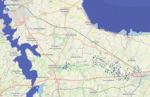
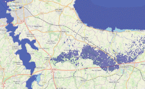
The flood.firetree.net website demonstrates which parts of France would be most affected by such a rise, showing particularly dramatic changes in the northern departments of Nord and Pas-de-Calais, Charente-Maritime and Gironde in the south west.
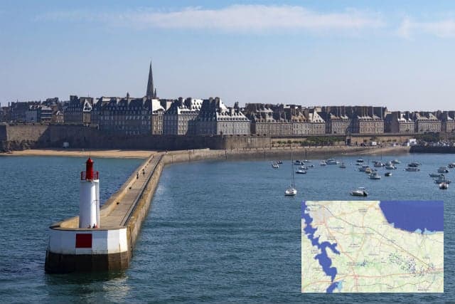
Among the towns and cities most at risk from rising sea levels in France are Bordeaux, Saint-Malo, Calais and Dunkirk.
Below is a comparison of Saint Malo now and after sea levels rise by two metres taken from flood.firetree.net.
 The Camargue, a beautiful natural territory on the Mediterranean coast would also change dramatically.
And while this might be the most pessimistic scenario, the signs are already there, with the sea advancing by eight metres year on year in the Camargue.
Even cities relatively far from the coast, such as Rouen, could see a large part of their urban areas flooded by the rising waters by 2100.
Back in 2015, organization Climate Central produced a global map which forecasts how coastlines will change due to global warming.
Their maps show the areas of the world most at risk and will become reality between now and 2200 if global temperatures increase by 2C or 4C.
As the maps below suggests, the impact could be particularly dramatic on the French coastline, with the areas in mid-blue representing those which will be lost to the sea and the oceans in the coming decades.
The Camargue, a beautiful natural territory on the Mediterranean coast would also change dramatically.
And while this might be the most pessimistic scenario, the signs are already there, with the sea advancing by eight metres year on year in the Camargue.
Even cities relatively far from the coast, such as Rouen, could see a large part of their urban areas flooded by the rising waters by 2100.
Back in 2015, organization Climate Central produced a global map which forecasts how coastlines will change due to global warming.
Their maps show the areas of the world most at risk and will become reality between now and 2200 if global temperatures increase by 2C or 4C.
As the maps below suggests, the impact could be particularly dramatic on the French coastline, with the areas in mid-blue representing those which will be lost to the sea and the oceans in the coming decades.
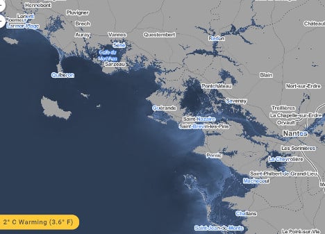
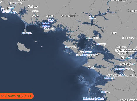
Southern Brittany/Loire Estuary
The Gulf of Morbihan on the southern coast of Brittany would be particularly badly hit as would the Loire estuary, with the cities of Nantes and Saint-Nazaire exposed to the rising waters.
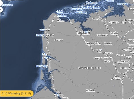
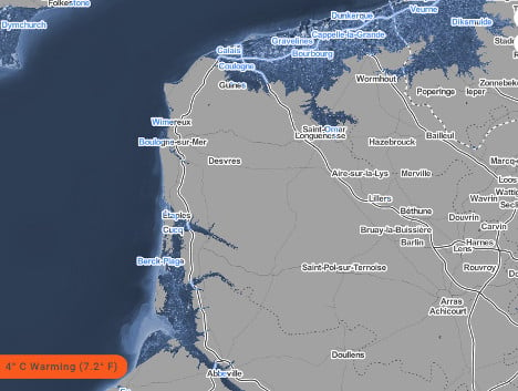
Calais / Dunkirk
The entrance to the Channel Tunnel might need more than a few sandbags considering it would be totally submerged, as would the towns of Calais and Dunkirk. Our great-great-grandchildren might need to dig a longer tunnel to get across the Channel - a much longer one, and probably a few new ports.
The mouth of the River Somme will have crept inland to the town of Abbeville, which currently stands around 20km away.
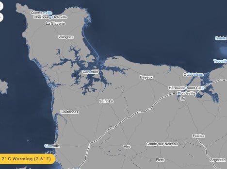
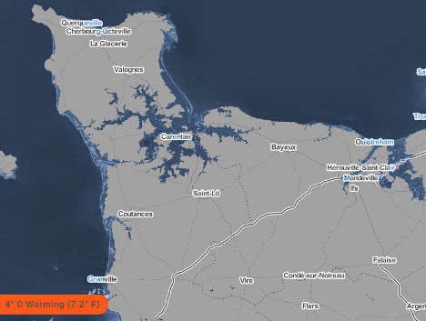
Normandy/Cotentin peninsular
The Cotentin Peninsular in Normandy would lose a lot of its land to the sea and with it some of the famous World War Two battle sites, with the map suggesting the town of Carentan could be underwater.
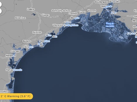
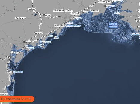
Mediterranean coast
The main threat in the south is around the western Mediterranean coast to the west of Marseille. The coast of Pyrénées-Orientales and Languedoc-Rousillon will recede dramatically, but it's around the Etang de Vaccares that the waters of the Med will soak up the most land with the town of Arles ending up pretty much sumerged.
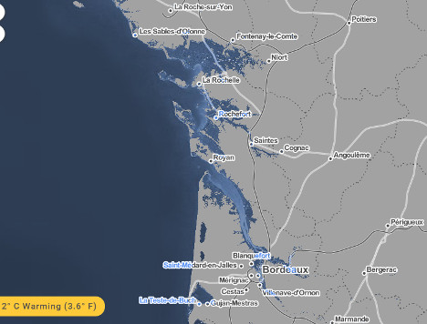
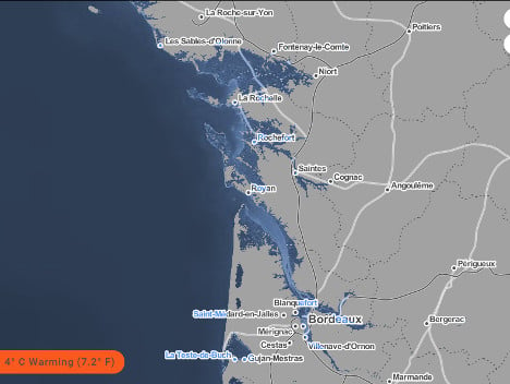
Atlantic coast
The Atlantic coast would be severely altered, with the Gironde Estuary widening dramatically and leaving part of the city of Bordeaux looking like Atlantis. Libourne would also be affected as the Dordogne and Garonne river beds grow dramatically.
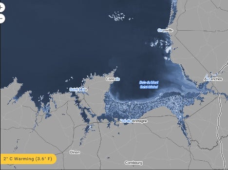
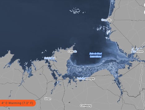
Mont Saint-Michel Bay
So much work has gone in to returning the famous island of Mont-Saint-Michel to the sea and restoring its natural maritime environment, that really it would have been cheaper just to wait for sea levels to rise.
Comments
See Also
Southern Brittany/Loire Estuary
The Gulf of Morbihan on the southern coast of Brittany would be particularly badly hit as would the Loire estuary, with the cities of Nantes and Saint-Nazaire exposed to the rising waters.
Calais / Dunkirk
The entrance to the Channel Tunnel might need more than a few sandbags considering it would be totally submerged, as would the towns of Calais and Dunkirk. Our great-great-grandchildren might need to dig a longer tunnel to get across the Channel - a much longer one, and probably a few new ports.
The mouth of the River Somme will have crept inland to the town of Abbeville, which currently stands around 20km away.
Normandy/Cotentin peninsular
The Cotentin Peninsular in Normandy would lose a lot of its land to the sea and with it some of the famous World War Two battle sites, with the map suggesting the town of Carentan could be underwater.
Mediterranean coast
The main threat in the south is around the western Mediterranean coast to the west of Marseille. The coast of Pyrénées-Orientales and Languedoc-Rousillon will recede dramatically, but it's around the Etang de Vaccares that the waters of the Med will soak up the most land with the town of Arles ending up pretty much sumerged.
Atlantic coast
The Atlantic coast would be severely altered, with the Gironde Estuary widening dramatically and leaving part of the city of Bordeaux looking like Atlantis. Libourne would also be affected as the Dordogne and Garonne river beds grow dramatically.
Mont Saint-Michel Bay
So much work has gone in to returning the famous island of Mont-Saint-Michel to the sea and restoring its natural maritime environment, that really it would have been cheaper just to wait for sea levels to rise.
Join the conversation in our comments section below. Share your own views and experience and if you have a question or suggestion for our journalists then email us at [email protected].
Please keep comments civil, constructive and on topic – and make sure to read our terms of use before getting involved.
Please log in here to leave a comment.