Heavy April snowfall heightens Swiss avalanche risk

UPDATED: Heavy snow caused problems for road and rail traffic in Switzerland on Thursday. The town of Andermatt in the canton of Uri was only accessible by train on Friday morning.
After a healthy dose of spring weather, winter made a return in the early hours of Wednesday with the country waking on Thursday to cold, wet – and sometimes white – conditions.
Vom #Frühling zum #Winter in 2 Tagen. Beispiel #Lauwil/BL: Am Dienstag #warm mit 18 Grad, heute #winterlich Weiss. Vielen Dank #SRFAugenzeuge F. Schweizer. ^is pic.twitter.com/qD4z0psIcf
— SRF Meteo (@srfmeteo) April 4, 2019
Up to a metre and a half of new snow has fallen in the Alps in the last 24 hours while the Swiss plateau also saw snowfall during the day on Thursday.
The heaviest snowfalls were seen in central Switzerland and in the western part of the canton of Ticino.
Traffic on the crucial north–south A2 axis was subject to regular delays during the day.
The town of Andermatt was cut off from the outside world on Thursday with train and road links closed because of the risk of avalanches. As of Friday morning, it was only reachable by train, according to Swiss media.
#andermatt ❄️ pic.twitter.com/YeBoPbeziK
— Flavio Bundi (@FlavioBundi) April 4, 2019
The snowfall is expected to stop overnight. However, the Swiss Institute for Snow and Avalanche Research (SLF) has issued a warning stating that the avalanche risk will be “high” (level 4 of 5) in some areas on Friday.
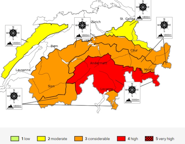
The avalanche risk in Switzerland for Friday April 5th. Image: SLF
Meanwhile, weather conditions across the country tomorrow will be far less wintry with temperatures ranging from 7–12C north of the Alps and hitting highs of 17C in Ticino.
Comments
See Also
After a healthy dose of spring weather, winter made a return in the early hours of Wednesday with the country waking on Thursday to cold, wet – and sometimes white – conditions.
Vom #Frühling zum #Winter in 2 Tagen. Beispiel #Lauwil/BL: Am Dienstag #warm mit 18 Grad, heute #winterlich Weiss. Vielen Dank #SRFAugenzeuge F. Schweizer. ^is pic.twitter.com/qD4z0psIcf
— SRF Meteo (@srfmeteo) April 4, 2019
Up to a metre and a half of new snow has fallen in the Alps in the last 24 hours while the Swiss plateau also saw snowfall during the day on Thursday.
The heaviest snowfalls were seen in central Switzerland and in the western part of the canton of Ticino.
Traffic on the crucial north–south A2 axis was subject to regular delays during the day.
The town of Andermatt was cut off from the outside world on Thursday with train and road links closed because of the risk of avalanches. As of Friday morning, it was only reachable by train, according to Swiss media.
#andermatt ❄️ pic.twitter.com/YeBoPbeziK
— Flavio Bundi (@FlavioBundi) April 4, 2019
The snowfall is expected to stop overnight. However, the Swiss Institute for Snow and Avalanche Research (SLF) has issued a warning stating that the avalanche risk will be “high” (level 4 of 5) in some areas on Friday.
The avalanche risk in Switzerland for Friday April 5th. Image: SLF
Meanwhile, weather conditions across the country tomorrow will be far less wintry with temperatures ranging from 7–12C north of the Alps and hitting highs of 17C in Ticino.
Join the conversation in our comments section below. Share your own views and experience and if you have a question or suggestion for our journalists then email us at [email protected].
Please keep comments civil, constructive and on topic – and make sure to read our terms of use before getting involved.
Please log in here to leave a comment.