Sweden’s cold snap disrupts flights and public transport
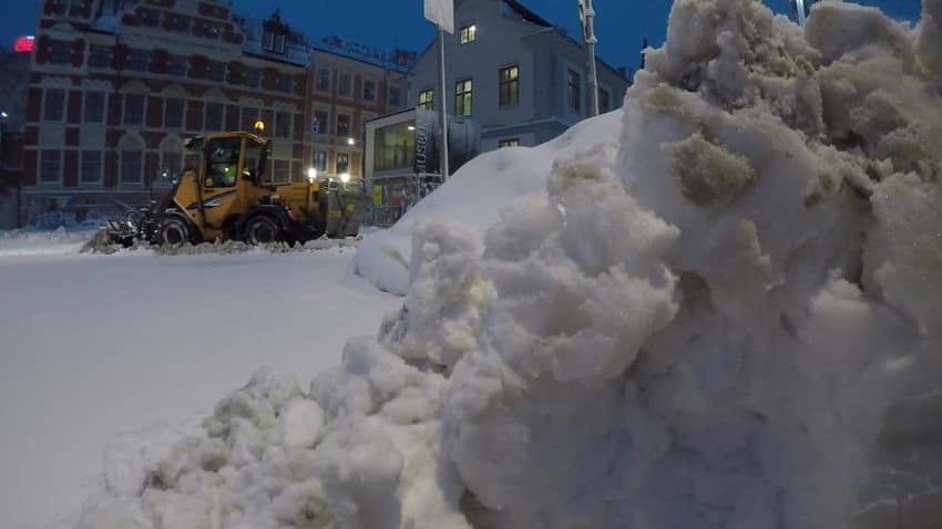
Delayed and cancelled flights, stricken public transport, blocked roads and power outages were all reported in the Stockholm area on Sunday as heavy snow caused major disruption.
The Swedish Transport Administration advised motorists to be wary of fallen trees related to heavy snow which continues to fall across the country.
Meanwhile, thousands suffered power outages in the Stockholm area on Sunday and public transport was brought to a standstill in several directions as severe winter weather disrupted infrastructure.
“The buses are getting stuck and can’t move. It is making roads dangerous,” Henrik Palmér of administrator Storstockholms Lokaltrafik (SL) told TT.
Winds and snow during the night also contributed to difficult conditions in the Blekinge area.
“There were a number of fallen trees and problems with level crossings, where bars did not function as they should due to snow and wind,” Katarina Wolffram of the Swedish Transport Administration said.
With windy weather reaching Stockholm on Sunday morning, Wolffram warned of fallen trees making smaller roads unpassable.
Motorists should try to keep to larger roads which have been cleared by snow plows, since smaller roads are not guaranteed to be cleared in such demanding conditions, she said.
“Wind can cause snow to drift over the roads, even if the plow passed only 10 minutes ago. Expect (journeys) to take longer, that there may be queues and take a warm jacket,” she said.
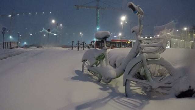
Photo: Marko Säävälä/TT
Heavy snow has caused power outages in the Stockholm area, with around 1,200 households in the Ekerö and Vallentuna districts experiencing blackouts on Sunday morning.
“This is not entirely surprising due to the heavy snowfall, unfortunately. We are prepared and have deployed more staff,” Jess Öllersten of distribution company Ellevio told TT.
Another power company, Vatenfall, said that up to 3,800 of its customers in the Stockholm area had experience power cuts by around 11am on Sunday.
“We have problems with soft snow settling on trees and branches, which then settles on cables,” the company’s head press officer Mikael Petrovic Wågmark said.
The Swedish capital’s public transport network was also disrupted by the weather on Sunday, with the city municipality warning of difficult travel conditions due to the weather and advising people to check travel information before departure.
-->
Läs mer på https://t.co/iqybZNYyTT
Felanmälan: https://t.co/h9zVwXCEHy
Väderprognoser: https://t.co/NDmaYkqOKp
Aktuell trafikinformation: https://t.co/hZsOwdCJHg
Kollektivtrafik: https://t.co/8tCdZrbRlm
Trafikverkets webbplats: https://t.co/2WDBkJbTCS.
— Stockholms stad (@Stockholmsstad) February 3, 2019
The Tunnelbanan underground rail was operating normally, but buses in many places were halted completely due to the conditions, Palmér said.
“It will be difficult to travel by public transport as well as other forms today, so perhaps you should carefully consider whether your journey is necessary,” the SL spokesperson said.
Rail connections and air traffic are both also subject to delays and cancellations.
Trains between Södertälje and Eskilstuna were stopped on Sunday morning and several flight departures from Stockholm Airport were cancelled, according to the Swedish Transport Administration and airport operator Swedavia respectively.
“We have delays of one hour or more and a number of canceled flights due to weather conditions. With so much snow, we need to clear snow and de-ice runways regularly,” Swedavia’s Lovisa Ernestam said.
Both arriving and departing flights are affected. Although Stockholm’s Arlanda Airport was most severely affected, subsequent delays may also result at other airports. Travellers are advised to check flight information before setting out.
Swedavia was unable to estimate the number of passengers who may be affected as of Sunday morning.
Meanwhile, the extreme weather will continue on Sunday, with 10-15 centimetres of snow forecast for most of the eastern part of the country.
Meteorological agency SMHI said it expects the snowfall to move gradually northwards, meaning that extreme weather warnings further south may gradually be lifted.
“To the north, low pressure will remain in place until Tuesday, but will ease off more and more,” SMHI meteorologist Henrik Reimert said.
Monday will see some clearing up in southern areas, although it will remain cold, Reimert also said.
“We will have a quite cold night going into Monday. In Götaland it could be down to -10°C and in Svealand down to -15°C,” he said.
On Tuesday, a new low pressure front will arrive from the west, but is not expected to bring weather as intense as that seen over the weekend, he added.
READ ALSO: 'Stay at home': Swedish emergency services warn public as weather worsens
Comments
See Also
The Swedish Transport Administration advised motorists to be wary of fallen trees related to heavy snow which continues to fall across the country.
Meanwhile, thousands suffered power outages in the Stockholm area on Sunday and public transport was brought to a standstill in several directions as severe winter weather disrupted infrastructure.
“The buses are getting stuck and can’t move. It is making roads dangerous,” Henrik Palmér of administrator Storstockholms Lokaltrafik (SL) told TT.
Winds and snow during the night also contributed to difficult conditions in the Blekinge area.
“There were a number of fallen trees and problems with level crossings, where bars did not function as they should due to snow and wind,” Katarina Wolffram of the Swedish Transport Administration said.
With windy weather reaching Stockholm on Sunday morning, Wolffram warned of fallen trees making smaller roads unpassable.
Motorists should try to keep to larger roads which have been cleared by snow plows, since smaller roads are not guaranteed to be cleared in such demanding conditions, she said.
“Wind can cause snow to drift over the roads, even if the plow passed only 10 minutes ago. Expect (journeys) to take longer, that there may be queues and take a warm jacket,” she said.
Photo: Marko Säävälä/TT
Heavy snow has caused power outages in the Stockholm area, with around 1,200 households in the Ekerö and Vallentuna districts experiencing blackouts on Sunday morning.
“This is not entirely surprising due to the heavy snowfall, unfortunately. We are prepared and have deployed more staff,” Jess Öllersten of distribution company Ellevio told TT.
Another power company, Vatenfall, said that up to 3,800 of its customers in the Stockholm area had experience power cuts by around 11am on Sunday.
“We have problems with soft snow settling on trees and branches, which then settles on cables,” the company’s head press officer Mikael Petrovic Wågmark said.
The Swedish capital’s public transport network was also disrupted by the weather on Sunday, with the city municipality warning of difficult travel conditions due to the weather and advising people to check travel information before departure.
-->
— Stockholms stad (@Stockholmsstad) February 3, 2019
Läs mer på https://t.co/iqybZNYyTT
Felanmälan: https://t.co/h9zVwXCEHy
Väderprognoser: https://t.co/NDmaYkqOKp
Aktuell trafikinformation: https://t.co/hZsOwdCJHg
Kollektivtrafik: https://t.co/8tCdZrbRlm
Trafikverkets webbplats: https://t.co/2WDBkJbTCS.
The Tunnelbanan underground rail was operating normally, but buses in many places were halted completely due to the conditions, Palmér said.
“It will be difficult to travel by public transport as well as other forms today, so perhaps you should carefully consider whether your journey is necessary,” the SL spokesperson said.
Rail connections and air traffic are both also subject to delays and cancellations.
Trains between Södertälje and Eskilstuna were stopped on Sunday morning and several flight departures from Stockholm Airport were cancelled, according to the Swedish Transport Administration and airport operator Swedavia respectively.
“We have delays of one hour or more and a number of canceled flights due to weather conditions. With so much snow, we need to clear snow and de-ice runways regularly,” Swedavia’s Lovisa Ernestam said.
Both arriving and departing flights are affected. Although Stockholm’s Arlanda Airport was most severely affected, subsequent delays may also result at other airports. Travellers are advised to check flight information before setting out.
Swedavia was unable to estimate the number of passengers who may be affected as of Sunday morning.
Meanwhile, the extreme weather will continue on Sunday, with 10-15 centimetres of snow forecast for most of the eastern part of the country.
Meteorological agency SMHI said it expects the snowfall to move gradually northwards, meaning that extreme weather warnings further south may gradually be lifted.
“To the north, low pressure will remain in place until Tuesday, but will ease off more and more,” SMHI meteorologist Henrik Reimert said.
Monday will see some clearing up in southern areas, although it will remain cold, Reimert also said.
“We will have a quite cold night going into Monday. In Götaland it could be down to -10°C and in Svealand down to -15°C,” he said.
On Tuesday, a new low pressure front will arrive from the west, but is not expected to bring weather as intense as that seen over the weekend, he added.
READ ALSO: 'Stay at home': Swedish emergency services warn public as weather worsens
Join the conversation in our comments section below. Share your own views and experience and if you have a question or suggestion for our journalists then email us at [email protected].
Please keep comments civil, constructive and on topic – and make sure to read our terms of use before getting involved.
Please log in here to leave a comment.