LATEST: Swathe of France gets new blanket of snow as big chill continues
More snow fell over France on Friday leaving a swathe of the country from Limousin to the Channel coast under a white blanket. Up to 10cm was forecast to fall on the Paris region which once again was hit by transport disruptions.
Main info:
-
Up to 10cm of snow expected in parts of central and northern France on Friday
-
Paris region forecast to get 7cm of snow
-
Drivers urged to leave cars at home
-
Eiffel Tower to remain closed until Sunday
-
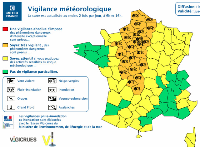
23 departments on alert for snow and ice in total on Friday afternoon
Snow was falling over much of France again on Friday with up to 10cm forecast in local areas.
In all, some 23 departments across the country were on alert for snow and ice including Paris, where motorists have once again been advised to leave their cars behind to avoid being caught up in traffic jams. Early reports suggested drivers had listened to the advice from police.
The snow began falling in Paris late morning and became heavier around lunchtime. It was set to continue until around 3pm by which time a fresh blanket of around 7cm of show will have coated the French capital, according to forecasts.
More snow has come to Paris...as promised. We might be freezing but it does look lovely! #ParisSousLaNeige pic.twitter.com/5X4aHKRxSF
— The Local France (@TheLocalFrance) February 9, 2018
In Paris the Metro service was running as normal but bus services in and around the capital began to be hit as the snow fell. Most buses were confined to their garages earlier in the week due to the fact the roads were not considered safe enough to navigate.
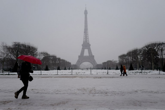
Tourism was also affected by the snow and freezing temperatures, with the Eiffel Tower announcing it would remain closed until Sunday.
But it wasn't just the Paris region that was affected by the latest snow showers. An area of the country stretching from Limousin in central France to the northern Channel coast is expected to get between 3cm and 7cm of snow.
The tweet below from Météo France shows the path of the snow across France from the west.
En ce moment || Les chutes de #neige progressent vers l'Est. Restez informés https://t.co/bbNAHFUEZc #VigilanceOrange #NeigeVerglas pic.twitter.com/uiqtNMFV6k
— Météo-France (@meteofrance) February 9, 2018
Nouvelle carte des cumuls de #neige attendus cet après-midi. Restez informés https://t.co/3PMCknwiMZ / @VigiMeteoFrance pic.twitter.com/lU8pDVUYDo
— Météo-France (@meteofrance) February 9, 2018
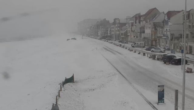
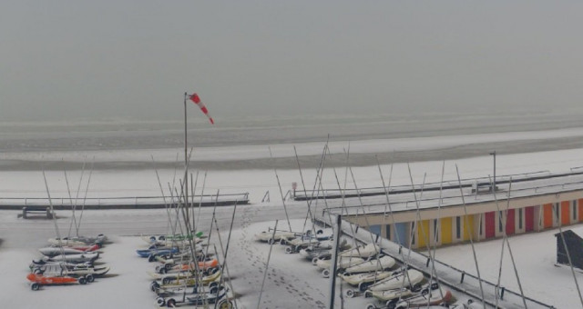
These images from La Chaine Météo were taken in the northern beach resort of Le Touquet where 3cm of snow had fallen. It is safe to say no one will be swimming today.
This was the scene in Yvelines to the west of Paris.
Les #Yvelines, où se trouvent nos locaux ont pris des allures de #paysage de #montagne. ❄️☃️? pic.twitter.com/OHLaqlbs0f
— La Chaîne Météo (@lachainemeteo) February 9, 2018
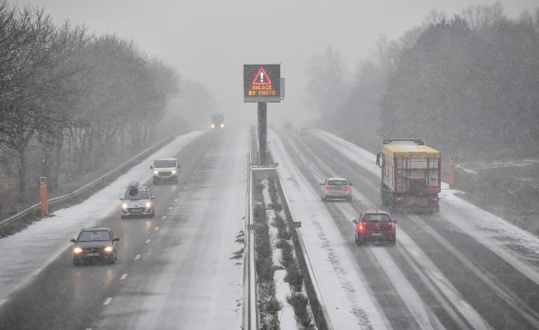
In several departments affected by the snow police were urging people not to travel by car and Heavy Goods Vehicles were banned from the main roads.
Vinci, one of the companies that runs France's motorway network was urging drivers to take care on autoroutes: A11, A28 and the A81. Conditions on the A16 in northern France were also said to be complicated.
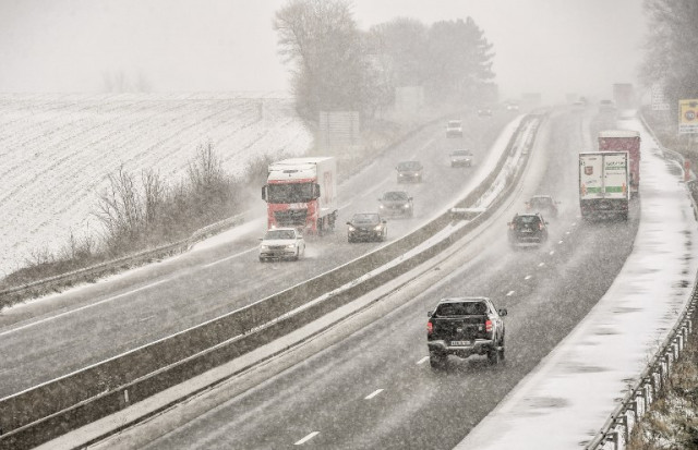
These images were taken on the A25 in northern France and on a road near the town of Meteren.
 (AFP)
(AFP)
 (AFP)
(AFP)
The images below were captured on the A13 between Paris and Rouen in Normandy and show that driving will be hazardous on Friday afternoon.
[EN DIRECT] La #neige recouvre la chaussée au péage de Buchelay sur l'autoroute A13, près de Mantes dans les Yvelines. Source : https://t.co/escVQhHAfU pic.twitter.com/3Eg8rZA5mu
— La Chaîne Météo (@lachainemeteo) February 9, 2018
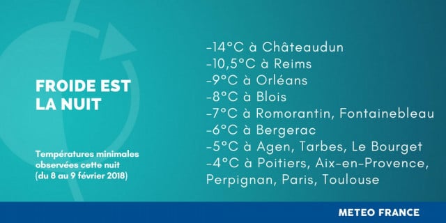
The snow came after what was reported to have been the coldest night of the winter in many parts of France.
Comments
See Also
Main info:
- Up to 10cm of snow expected in parts of central and northern France on Friday
- Paris region forecast to get 7cm of snow
- Drivers urged to leave cars at home
- Eiffel Tower to remain closed until Sunday
- 23 departments on alert for snow and ice in total on Friday afternoon
Snow was falling over much of France again on Friday with up to 10cm forecast in local areas.
In all, some 23 departments across the country were on alert for snow and ice including Paris, where motorists have once again been advised to leave their cars behind to avoid being caught up in traffic jams. Early reports suggested drivers had listened to the advice from police.
The snow began falling in Paris late morning and became heavier around lunchtime. It was set to continue until around 3pm by which time a fresh blanket of around 7cm of show will have coated the French capital, according to forecasts.
More snow has come to Paris...as promised. We might be freezing but it does look lovely! #ParisSousLaNeige pic.twitter.com/5X4aHKRxSF
— The Local France (@TheLocalFrance) February 9, 2018
In Paris the Metro service was running as normal but bus services in and around the capital began to be hit as the snow fell. Most buses were confined to their garages earlier in the week due to the fact the roads were not considered safe enough to navigate.
Tourism was also affected by the snow and freezing temperatures, with the Eiffel Tower announcing it would remain closed until Sunday.
But it wasn't just the Paris region that was affected by the latest snow showers. An area of the country stretching from Limousin in central France to the northern Channel coast is expected to get between 3cm and 7cm of snow.
The tweet below from Météo France shows the path of the snow across France from the west.
En ce moment || Les chutes de #neige progressent vers l'Est. Restez informés https://t.co/bbNAHFUEZc #VigilanceOrange #NeigeVerglas pic.twitter.com/uiqtNMFV6k
— Météo-France (@meteofrance) February 9, 2018
Nouvelle carte des cumuls de #neige attendus cet après-midi. Restez informés https://t.co/3PMCknwiMZ / @VigiMeteoFrance pic.twitter.com/lU8pDVUYDo
— Météo-France (@meteofrance) February 9, 2018
These images from La Chaine Météo were taken in the northern beach resort of Le Touquet where 3cm of snow had fallen. It is safe to say no one will be swimming today.
This was the scene in Yvelines to the west of Paris.
Les #Yvelines, où se trouvent nos locaux ont pris des allures de #paysage de #montagne. ❄️☃️? pic.twitter.com/OHLaqlbs0f
— La Chaîne Météo (@lachainemeteo) February 9, 2018
In several departments affected by the snow police were urging people not to travel by car and Heavy Goods Vehicles were banned from the main roads.
Vinci, one of the companies that runs France's motorway network was urging drivers to take care on autoroutes: A11, A28 and the A81. Conditions on the A16 in northern France were also said to be complicated.
These images were taken on the A25 in northern France and on a road near the town of Meteren.
(AFP)
(AFP)
The images below were captured on the A13 between Paris and Rouen in Normandy and show that driving will be hazardous on Friday afternoon.
[EN DIRECT] La #neige recouvre la chaussée au péage de Buchelay sur l'autoroute A13, près de Mantes dans les Yvelines. Source : https://t.co/escVQhHAfU pic.twitter.com/3Eg8rZA5mu
— La Chaîne Météo (@lachainemeteo) February 9, 2018
The snow came after what was reported to have been the coldest night of the winter in many parts of France.
Join the conversation in our comments section below. Share your own views and experience and if you have a question or suggestion for our journalists then email us at [email protected].
Please keep comments civil, constructive and on topic – and make sure to read our terms of use before getting involved.
Please log in here to leave a comment.