Snow forecast to hit much of France this week
The Local France - [email protected]
Published: 27 Nov, 2017 CET.
Updated: Mon 27 Nov 2017 10:02 CET

It will begin to look a lot like Christmas in France this week with a large part of the country, including Paris, expected to get its first dusting of snow from Wednesday onwards.
It might be time to dig out your snow shovel.
The mountains have already had their fair share of snow but between Wednesday and Saturday it is expected to fall on lower ground around the country.
Coinciding with the official start of winter on December 1st, the snowfall is expected to start in the east of the country, with a moderate chance it will spread west.
By Friday morning Paris could find itself under a white blanket with snow showers forecast in the early hours. However it is unlikely to hang around for long with temperatures to rise above 0C throughout the day, so if Paris does get some snow, it will likely melt away.
Le risque de chutes de #neige en #plaine est confirmé cette #semaine. C'est dans l'Est, entre #mercredi et #samedi, que le risque de tenue temporaire de neige en plaine est le plus important. pic.twitter.com/JL96A0H3hl
— La Chaîne Météo (@lachainemeteo) 26 novembre 2017
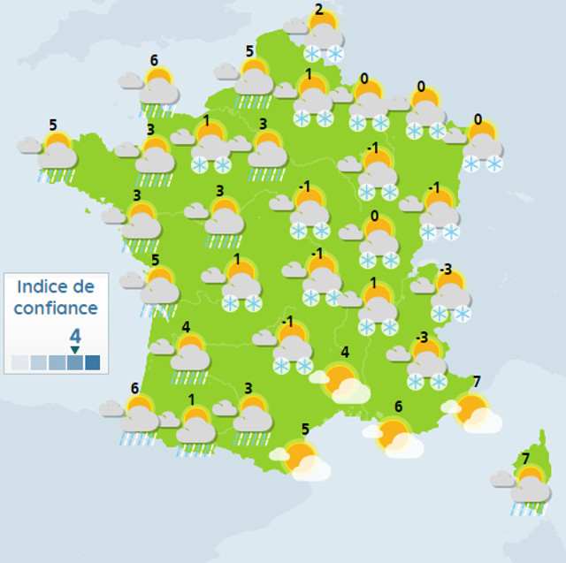
The map below by Keraunos, the French tornadoes and violent storms observatory, shows the amount of cumulative snow expected.
Semaine à venir hivernale. Voici la moyenne des 50 membres du modèle européen concernant les chutes de neige pour la semaine prochaine. Le signal pour une couche de neige au sol d'ici la fin de semaine pro est significatif. pic.twitter.com/UqLgMdtlg5
— Keraunos (@KeraunosObs) 26 novembre 2017
France's national weather agency Météo France is also confident of widespread snowfall.
 Weather on Wednesday afternoon. Map: Météo France
If the forecast is correct snow will hit all the way from Hauts-de-France in the north east to Nouvelle Aquitaine in the south east.
Temperatures however are not expected to drop far below zero.
Overnight on Wednesday, the snow is likely to spread towards the Massif Central.
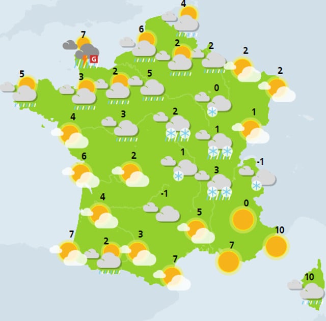
Weather on Wednesday afternoon. Map: Météo France
If the forecast is correct snow will hit all the way from Hauts-de-France in the north east to Nouvelle Aquitaine in the south east.
Temperatures however are not expected to drop far below zero.
Overnight on Wednesday, the snow is likely to spread towards the Massif Central.
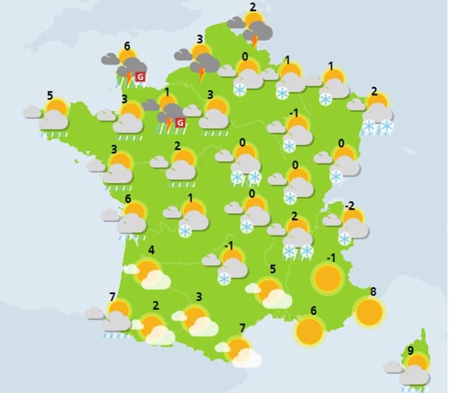 Weather on Thursday afternoon. Map: Météo France
And from Thursday night and throughout Friday the snow is expected to be at its peak.
Weather on Thursday afternoon. Map: Météo France
And from Thursday night and throughout Friday the snow is expected to be at its peak.
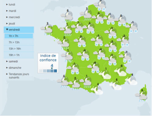
 Weather on Friday afternoon. Map: Météo France
Next weekend, more snow showers are expected to continue across much of the eastern part of the country.
Weather on Friday afternoon. Map: Météo France
Next weekend, more snow showers are expected to continue across much of the eastern part of the country.
Comments
See Also
It might be time to dig out your snow shovel.
The mountains have already had their fair share of snow but between Wednesday and Saturday it is expected to fall on lower ground around the country.
Coinciding with the official start of winter on December 1st, the snowfall is expected to start in the east of the country, with a moderate chance it will spread west.
By Friday morning Paris could find itself under a white blanket with snow showers forecast in the early hours. However it is unlikely to hang around for long with temperatures to rise above 0C throughout the day, so if Paris does get some snow, it will likely melt away.
Le risque de chutes de #neige en #plaine est confirmé cette #semaine. C'est dans l'Est, entre #mercredi et #samedi, que le risque de tenue temporaire de neige en plaine est le plus important. pic.twitter.com/JL96A0H3hl
— La Chaîne Météo (@lachainemeteo) 26 novembre 2017
The map below by Keraunos, the French tornadoes and violent storms observatory, shows the amount of cumulative snow expected.
Semaine à venir hivernale. Voici la moyenne des 50 membres du modèle européen concernant les chutes de neige pour la semaine prochaine. Le signal pour une couche de neige au sol d'ici la fin de semaine pro est significatif. pic.twitter.com/UqLgMdtlg5
— Keraunos (@KeraunosObs) 26 novembre 2017
France's national weather agency Météo France is also confident of widespread snowfall.
Weather on Wednesday afternoon. Map: Météo France
If the forecast is correct snow will hit all the way from Hauts-de-France in the north east to Nouvelle Aquitaine in the south east.
Temperatures however are not expected to drop far below zero.
Overnight on Wednesday, the snow is likely to spread towards the Massif Central.
Weather on Thursday afternoon. Map: Météo France
And from Thursday night and throughout Friday the snow is expected to be at its peak.
Weather on Friday afternoon. Map: Météo France
Next weekend, more snow showers are expected to continue across much of the eastern part of the country.
Join the conversation in our comments section below. Share your own views and experience and if you have a question or suggestion for our journalists then email us at [email protected].
Please keep comments civil, constructive and on topic – and make sure to read our terms of use before getting involved.
Please log in here to leave a comment.