Rare map found in Sweden to be displayed in Australia
A rare map found in an attic in Sweden in 2010 is going on display in Australia following a delicate conservation process.
It was purchased by the National Library of Australia in 2013, and after a short exhibition period at the time, has undergone a thorough conservation effort. Now, it's ready to be displayed again.
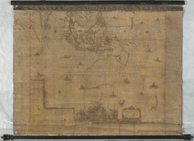
The map is called Archipelagus Orientalis, sive Asiaticus, Latin for ‘The Eastern or Asian Archipelago’, and was created in 1663 by renowned Dutch cartographer Joan Blaeu. Blaeu was the official cartographer of the Dutch East Indian Company, and his works portrayed the extent of Dutch power in the 17th century.
It depicts Hollandia Nova, or New Holland, as mainland Australia was known before the British settlement. All subsequent maps of New Holland were based on this work by Blaeu, and the map is considered “the birth certificate of New Holland” by many in the West.
A text printed on the map tells the story of explorer Abel Tasman’s two voyages in 1642 and 1644. Tasman is known for being the first European to reach Van Diemen’s Land (now Tasmania), New Zealand, and to sight the Fiji islands, and his sighting of Tasmania in 1642, is depicted on the map.
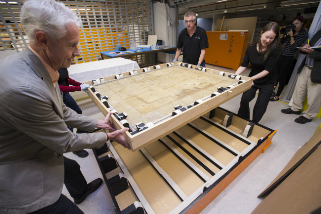
The map being prepared for transport. Photo: National Library of Australia.
It is one of only four known copies, and the only one to have come to light since the 17th century. Its existence was not known of until the map was discovered in an attic in Stockholm in 2010.
According to the National Library, there are no records of the map in any catalogues since it was printed, with the exception of one listing in the collection of antiquarian Thulin of Amsterdam, as early as 1950. Exactly how the map made its way to Sweden is unknown.
The map was first put to auction for a modest price at a small auction house in Sweden, and was acquired by a private vendor who recognized it as a Blaeu and offered it to the National Library of Australia. In 2013, it was purchased in 2013 with the help of the Australian government. The amount paid by the Library was not made public, but the map has been described as “priceless”. An earlier print of the map sold this year for £ 248,750 ($ 321,708) by Sotheby’s.
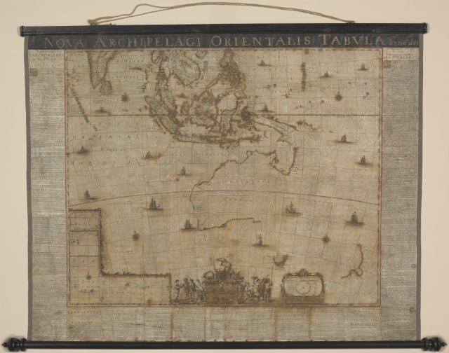
The Archipelagus Orientalis after the conservation process. Photo: National Library of Australia
It was first displayed at an exhibit in 2013, but further conservation work was needed because the paper had been damaged by the corrosive green pigment used in the production of the map, verdigris.
The Library successfully raised funds in 2014 to complete the process. Experts removed the varnish, which had become yellow and brittle, repaired the backing of the map, and reattached and the original display rods.
The map was then digitized and a custom-made housing was developed for it.
It will be on display until mid-next year at the National Library of Australia in Canberra.
The map isn’t the only rare discovery to have been made in a Swedish attic. Recently, a watch found by a man cleaning up after his father’s death made headlines for breaking records in the auction world.
Comments
See Also
It was purchased by the National Library of Australia in 2013, and after a short exhibition period at the time, has undergone a thorough conservation effort. Now, it's ready to be displayed again.
The map is called Archipelagus Orientalis, sive Asiaticus, Latin for ‘The Eastern or Asian Archipelago’, and was created in 1663 by renowned Dutch cartographer Joan Blaeu. Blaeu was the official cartographer of the Dutch East Indian Company, and his works portrayed the extent of Dutch power in the 17th century.
It depicts Hollandia Nova, or New Holland, as mainland Australia was known before the British settlement. All subsequent maps of New Holland were based on this work by Blaeu, and the map is considered “the birth certificate of New Holland” by many in the West.
A text printed on the map tells the story of explorer Abel Tasman’s two voyages in 1642 and 1644. Tasman is known for being the first European to reach Van Diemen’s Land (now Tasmania), New Zealand, and to sight the Fiji islands, and his sighting of Tasmania in 1642, is depicted on the map.
The map being prepared for transport. Photo: National Library of Australia.
It is one of only four known copies, and the only one to have come to light since the 17th century. Its existence was not known of until the map was discovered in an attic in Stockholm in 2010.
According to the National Library, there are no records of the map in any catalogues since it was printed, with the exception of one listing in the collection of antiquarian Thulin of Amsterdam, as early as 1950. Exactly how the map made its way to Sweden is unknown.
The map was first put to auction for a modest price at a small auction house in Sweden, and was acquired by a private vendor who recognized it as a Blaeu and offered it to the National Library of Australia. In 2013, it was purchased in 2013 with the help of the Australian government. The amount paid by the Library was not made public, but the map has been described as “priceless”. An earlier print of the map sold this year for £ 248,750 ($ 321,708) by Sotheby’s.
The Archipelagus Orientalis after the conservation process. Photo: National Library of Australia
It was first displayed at an exhibit in 2013, but further conservation work was needed because the paper had been damaged by the corrosive green pigment used in the production of the map, verdigris.
The Library successfully raised funds in 2014 to complete the process. Experts removed the varnish, which had become yellow and brittle, repaired the backing of the map, and reattached and the original display rods.
The map was then digitized and a custom-made housing was developed for it.
It will be on display until mid-next year at the National Library of Australia in Canberra.
The map isn’t the only rare discovery to have been made in a Swedish attic. Recently, a watch found by a man cleaning up after his father’s death made headlines for breaking records in the auction world.
Join the conversation in our comments section below. Share your own views and experience and if you have a question or suggestion for our journalists then email us at [email protected].
Please keep comments civil, constructive and on topic – and make sure to read our terms of use before getting involved.
Please log in here to leave a comment.